A Geographic Information Systems-Based Analysis of Response
Time and Hospital Coverage Area in Sukhothai Province, Thailand
Thipthimwong, K., Panawathanapisuit, S.,* Thonthong,
T., Yamsri, T. and Plubplatong, T.
Faculty of Nursing, Kamphaeng Phet Rajabhat University, 62000,
Kamphaeng Phet, Thailand

*Corresponding Author
Abstract
In this study, Geographic Information Systems (GIS) were employed
to analyze emergency medical services (EMS) coverage and response
times in Sukhothai Province, Thailand. The primary objective was to
evaluate the efficiency and reach of EMS in different districts,
taking into consideration various response time scenarios.
Utilizing ArcMap software, buffer zones were created around
hospitals to represent EMS coverage areas based on distances
corresponding to response times of 5, 8, 10, 15, 20, and 25
minutes. The research employs buffer zones to calculate coverage
areas for response times ranging from 5 to 30 minutes, based on an
average EMS speed of 40 kph. Findings reveal significant variations
in EMS coverage, with densely populated areas generally well-served
within a 20-minute response time, while remote and mountainous
regions face substantial access challenges. Even at a 30-minute
response time, 17.23% of the province remains uncovered, primarily
in mountainous areas. The study highlights that no district
achieves full coverage within a 10-minute response time,
particularly in peripheral sub-districts. Analysis of
district-level data exposes stark disparities, with smaller
districts like Si Nakhon showing higher coverage percentages
compared to larger, more challenging terrains such as Si
Satchanalai. These results emphasize the need for targeted
improvements in EMS infrastructure, resource allocation, and
innovative solutions to ensure equitable access to emergency care
across Sukhothai Province. The study provides valuable insights for
policymakers and healthcare planners to optimize EMS deployment and
enhance emergency response capabilities in the region.
Keywords: Coverage Area, Emergency Medical Services
(EMS), Emergency Response Strategy, Healthcare Delivery, Response Time
1. Introduction
The emergency medical system was developed to minimize deaths, alleviate
suffering from accidents, and reduce the costs associated with delays in
patient care. It aims to prevent improper transportation and ensure that
patients are directed to appropriate hospitals. For the public to
benefit from this system, operators must provide timely assistance,
thereby helping to prevent deaths and disabilities among emergency
patients [1]. An effective emergency medical center requires adequate
resources, including qualified personnel and facilities equipped for
emergency treatment. Prompt care can be life-saving or prevent severe
complications before patients reach the hospital. Emergency medical
units operate 24/7, with a central reporting center that dispatches the
appropriate team based on the situation to assist and transport
patients to hospitals. This system, known as the Emergency Medical
Service (EMS), is crucial for saving lives [2].
In Thailand, EMS units are present in every province, but their
capabilities and effectiveness vary. Differences in operating systems,
personnel, equipment, protocols, and management practices can impact
service quality Response time in Emergency Medical Services (EMS) is a
critical metric that measures the duration from when an emergency call is
received to when EMS personnel arrive at the scene. Faster response times
are crucial for improving patient outcomes, especially in time-sensitive
emergencies such as cardiac arrests, strokes, or trauma. Quick arrival of
EMS can significantly impact the effectiveness of medical interventions and
increase the likelihood of survival and recovery.
Additionally, the Ministry of Public Health mandates that emergency
medical services should reach the scene within 8 to 10 minutes, but some
patients may not receive timely assistance. Statistically, the
percentage of critically ill patients receiving emergency treatment at
the scene within 8 minutes decreased from 49.76% in 2012 to 32.3% in
2022, but then increased slightly to 41.03% in 2023 [3].
The National Institute for Emergency Medicine (NIEM) was officially
established in Thailand in 2008 under Section 14 of the National
Emergency Medicine Act [4]. As a public organization, NIEM is tasked
with managing and coordinating efforts between government and private
agencies. Its primary mission is to reduce mortality and minimize
medical costs associated with delays in providing initial care at the
scene of emergencies. By improving the efficiency of first aid and
subsequent transfer to hospitals, NIEM aims to address the increasing
number of critically ill emergency patients and enhance overall
emergency medical response. In Emergency Medical Services (EMS),
response time is a critical metric that measures the efficiency and
effectiveness of emergency response. It refers to the total duration
from when an emergency call is received by the dispatch center to the
moment the EMS team arrives at the scene of the incident. This
timeframe typically includes [5]:
-
Call Receipt Time: The moment the emergency call is answered
by the dispatch center.
-
Dispatch Time: The interval from when the call is received to
when the appropriate EMS team is dispatched.
-
Travel Time: The duration it takes for the EMS unit to reach
the scene from the time it is dispatched.
Response time is a key indicator of the quality of emergency medical
services, as it directly impacts the outcomes of emergency care. Faster
response times are crucial for timely intervention, which can
significantly affect patient survival rates and recovery, especially in
life-threatening situations. Reducing response times is a major goal
for EMS systems to improve patient outcomes and overall service
efficiency [6]. In recent years, the optimization of healthcare
services has become a pivotal concern for regional development,
particularly in underserved and remote areas. Geographic Information
Systems (GIS) offer a powerful toolset for analyzing spatial data,
enabling detailed assessments of healthcare accessibility and response
times [7] and [8]. This study focuses on Sukhothai Province, Thailand,
a region where healthcare coverage and response times are critical for
improving public health outcomes.
Sukhothai Province, located in northern Thailand, is characterized by a
diverse topography that ranges from mountainous regions to flat plains.
This geographical variability poses unique challenges for healthcare
service delivery, including issues related to hospital accessibility
and emergency response efficiency. Despite significant advances in
healthcare infrastructure, disparities in service availability and
response times persist, impacting the quality of care received by
residents. The objective of this research is to utilize GIS-based
analysis to assess the spatial distribution of hospitals and evaluate
their coverage areas in relation to emergency response times within
Sukhothai Province. By mapping the locations of healthcare facilities
and analyzing their service areas, we aim to identify gaps in coverage
and areas where response times are suboptimal. This analysis seeks to
provide actionable insights that can inform policy decisions and improve
healthcare delivery strategies in the province.
This research emphasizes the critical importance of timely access to
incident areas for providing emergency medical services. To address
this, Geographic Information Systems (GIS) are utilized to analyze the
coverage area of emergency medical services in Sukhothai Province. The
analysis is conducted based on the response time requirements set by
the EMS Office. By employing GIS, the study aims to clearly delineate
service areas, enhancing both access and effectiveness in delivering
life-saving care to patients. Through this study, we hope to contribute
to a more nuanced understanding of the spatial dynamics of healthcare
access in Sukhothai, ultimately supporting efforts to enhance the
efficiency and effectiveness of healthcare services in the region.
2. Study Area
Sukhothai Province, located in northern Thailand at the latitudes of
16°40′N to 17°50′N and, the longitudes of 95°18′E to 100°12′E as
illustrates in Figure 1(a), bordered by Phitsanulok to the east,
Kamphaeng Phet to the west, Tak to the north, and Uttaradit to the
south [9]. The province has the total area of 6,596 sq.km. and divided
into 9 districts as depicts in Figure 1(a) with the total population of
approximately 700,000 people [10]. Sukhothai’s demographic distribution
varies from dense urban areas around Sukhothai city to more sparsely
populated rural regions. The population numbers of each district in the
province depicts in Figure 1(b). Each district has a hospital located
within its boundaries, with the hospital's name corresponding to the
district's name.
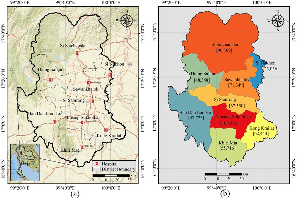
Figure 1: Sukhothai province, Thailand (a) Geographic
location (b) Population numbers
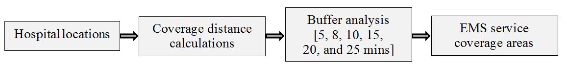
Figure 2: EMS service coverage area analysis
Table 1: Relation between response time and distance
at an average speed of 40 kph
|
Time (mins)
|
5
|
8
|
10
|
15
|
20
|
25
|
30
|
|
Distance (km)
|
3.33
|
5.33
|
6.67
|
10.00
|
13.33
|
16.67
|
20.00
|
3. Methodology
To assess hospital coverage areas and response times in Sukhothai
Province, this study employs Geographic Information Systems (GIS) to
provide a comprehensive spatial analysis. The study work flow presents
in Figure 2. The methodology involves mapping the locations of the
hospitals across the province. The locations were acquired from Google
map available at https://google.com/maps. The coverage area is
determined from Equation 1:

Equation 1
Where: d = distance that corresponding to response time (km)
v= average velocity of EMS service (km/min)
t = response time (min)
The maximum speed for EMS services in Thailand is limited to 80 kph
[11]. However, this speed cannot be consistently maintained due to
factors such as traffic, road conditions, and turning points.
Consequently, an average speed of 40 kph (0.667 km/min) was used in
this study. The relationship between distance and response time is
shown in Table 1.
The distances in Table 1 were used to determine the coverage area
radiating from each hospital in the study area. The analysis utilized
the buffer geoprocessing tool in ArcMap software to calculate these
coverage areas from the buffered zones. The buffer tool in Geographic
Information Systems (GIS) is a powerful spatial analysis tool used to
create a zone of a specified distance around a geographic feature, such
as a point, line, or polygon. This zone, or buffer, represents the area
within a certain distance from the feature and is useful for analyzing
proximity and accessibility [12]. The application in coverage area
determination of the Buffer Tool are as follows:
-
Distance Measurement: The buffer tool allows users to define a
specific distance around a feature. For example, if a hospital is
the feature, a buffer of 5 kilometers can be created to show the
area within 5 kilometers of that hospital.
-
Zone Creation: The tool generates a new layer in the GIS with
the buffered zone. This zone is essentially a polygon that
outlines the area around the original feature, which can be adjusted
for various distances depending on the analysis needs [13].
-
Healthcare Facility Analysis: In the context of analyzing
hospital coverage areas, the buffer tool can be used to
visualize and measure the reach of healthcare facilities. For
instance, by creating buffers around each hospital with a
radius corresponding to response time targets (e.g., 8 minutes
or 10 minutes), analysts can determine the geographic extent
within which emergency medical services should ideally reach
patients.
-
Service Area Mapping: Buffers help in mapping the service
areas of hospitals, enabling the identification of regions that
fall within or outside these areas. This is crucial for
understanding coverage gaps and ensuring that all regions,
especially underserved or remote areas, have adequate access
to emergency medical services [14].
-
Accessibility Analysis [15]: By overlaying multiple buffers
for different hospitals, GIS can show the cumulative coverage and
highlight areas where services overlap or where there is a lack of
coverage. This helps in evaluating the effectiveness of the current
service distribution and planning improvements.
-
Response Time Assessment: Buffers can also be used to assess
response times. By creating buffers around emergency service units
or hospitals based on the average travel time, analysts can
visualize which areas are covered within the acceptable
response time and identify any regions that may require
additional resources or adjustments in service delivery.
In summary, the buffer tool in GIS is essential for determining and
visualizing coverage areas around key facilities, such as hospitals. It
provides valuable insights into spatial accessibility and helps in
planning and optimizing emergency medical services to ensure timely and
effective care for all regions. This approach allows for a detailed
understanding of the accessibility and efficiency of emergency care,
supporting targeted improvements and strategic planning.
4. Results and Discussion
The coverage areas of each hospital within the study area were
calculated using the buffer zones illustrated in Figure 3. The figure
shows that EMS coverage areas for response times of 5, 8, and 10
minutes encompass the areas surrounding each hospital within their
respective districts. However, the entire district is not covered by
the 10-minute response time, as depicted in Figure 3(a) to Figure 3(c).
For a response time of 15 minutes (10 km radius), the overlapping EMS
coverage areas are primarily on the eastern side of the province. Three
districts—Sai Satchanalai, Thung Saliam, and Ban Dan Lan Hoi—do not
overlap with the other six districts in Sukhothai province (Figure
3(d)). At a 20-minute response time (13.33 km radius), all EMS coverage
areas are interconnected, except for Thung Saliam hospital (Figure
3(e)). By a 25-minute response time, the EMS coverage areas of each
hospital overlap, as shown in Figures 3(f) and 4(g). Detailed EMS
coverage areas for the corresponding response times and distances are
presented in Table 2.
Access to the incident area for emergency medical services (EMS), as
specified by the Ministry of Public Health, should be within 8 to 10
minutes, with a maximum coverage distance of approximately 10 km. This
distance is based on the allowable maximum speed of EMS, which is 80
kph. However, maintaining this speed consistently is challenging due to
factors such as road conditions, traffic, weather, topography, driver
skill and behavior, vehicle load, route efficiency, and altitude.
Previous studies indicate that the average speed of EMS in urban areas
is approximately 34 kph. Consequently, an average speed of 40 kph was
used to determine the EMS coverage area. Table 2 presents the EMS
(Emergency Medical Services) coverage areas corresponding to various
response times and distances.
The data reveals a direct relationship between response time and
coverage area. Specifically, with a response time of 5 minutes, EMS
services cover an area of 302.77 square kilometers, which constitutes
4.59% of the total area. As the response time increases to 8 minutes,
the coverage area expands to 765.28 square kilometers, or 11.60% of the
region. At a 10-minute response time, the EMS can cover 1,194.83 square
kilometers, accounting for 18.11% of the total area.
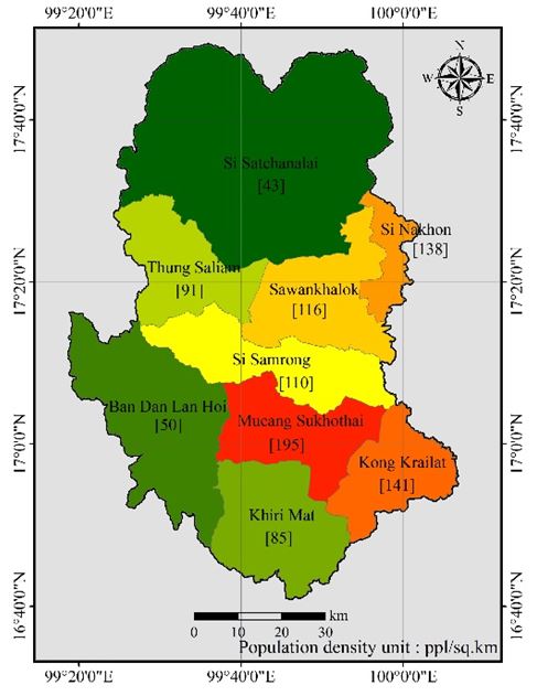
Figure 3: EMS coverage areas determined from response
time (a) 5 minutes (b) 8 minutes (c) 10 minutes (d) 15 minutes (e) 20 minutes (f) 25 minutes and (g) 30 minutes
Table 2: EMS coverage areas for the corresponding
response times and distances
|
No.
|
Response time (min)
|
EMS distance (km)
|
EMS coverage area [sq.km]
|
Percentage of EMS coverage area [%]
|
|
1
|
5
|
3.33
|
302.77
|
4.59
|
|
2
|
8
|
5.33
|
765.28
|
11.60
|
|
3
|
10
|
6.67
|
1,194.83
|
18.11
|
|
4
|
15
|
10.00
|
2,611.72
|
39.60
|
|
5
|
20
|
13.33
|
3,941.28
|
59.75
|
|
6
|
25
|
16.67
|
4,912.18
|
74.47
|
|
7
|
30
|
20.00
|
5,459.38
|
82.77
|
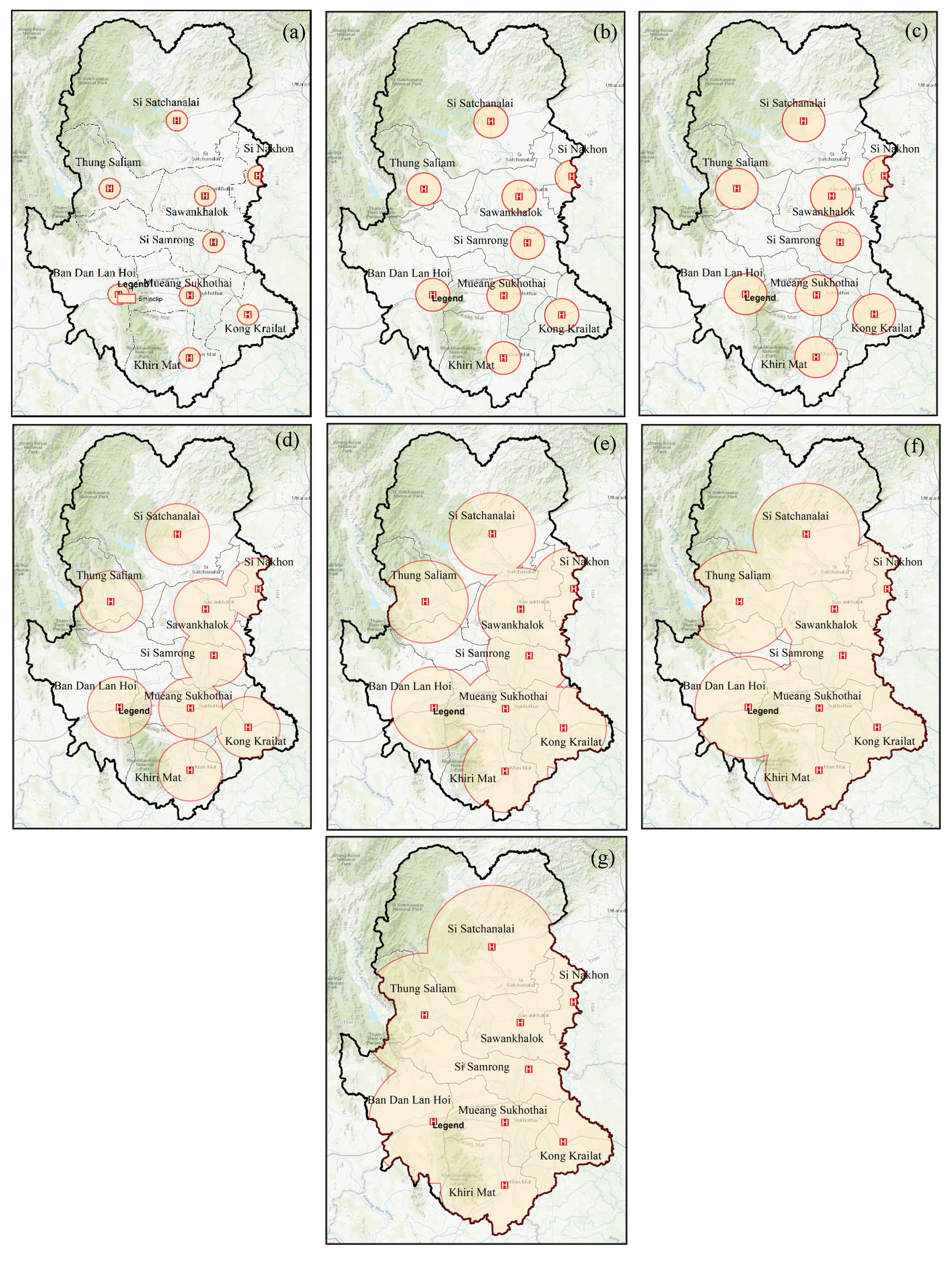
Figure 4: Population density by district in Sukhothai
province
However, it becomes evident that a response time of 10 minutes is
insufficient to provide coverage throughout the individual districts
within the study area. A significantly larger portion of the area,
82.77%, is covered when the response time is extended to 30 minutes,
corresponding to 5,459.38 square kilometers. Despite this extensive
coverage, certain mountainous regions in the northern and eastern parts
of the province, particularly in Si Satchanalai and Ban Dan Lan Hoi
districts, remain outside the reach of EMS services. This indicates
that topographical challenges and the distribution of EMS resources
limit the effectiveness of emergency response in these areas. The
diminishing marginal increase in coverage area percentage as response
times extend suggests that while longer response times allow for
greater coverage, the benefits reduce as the area approaches full
coverage. This highlights the importance of balancing response times
with practical resource allocation to optimize EMS efficiency and
effectiveness.
Figure 4 highlights that high population density areas in Sukhothai
Province include Mueang Sukhothai, Kong Krailat, Si Nakhon,
Sawankholok, and Si Samrong districts, with population densities of
195, 141, 138, 116, and 110 people per square kilometer, respectively.
These densely populated areas are covered within a 20-minute response
time, as shown in Figure 5(e). As previously noted, this study uses an
average speed of 40 kph, however, increasing the average speed would
reduce the response time in these densely populated areas to less than
20 minutes. The coverage areas for 5, 8, and 10 minutes shown in Figures
5(a) to 5(c) are too small and lack detail. To better illustrate the
coverage areas for these response times, detailed maps of EMS coverage
for each district are provided in Figure 5. The figure shows the EMS
coverage areas for 5, 8, and 10-minute response times across all 9
districts in Sukhothai Province. It is evident that hospitals are
strategically located within the city and near major roads.
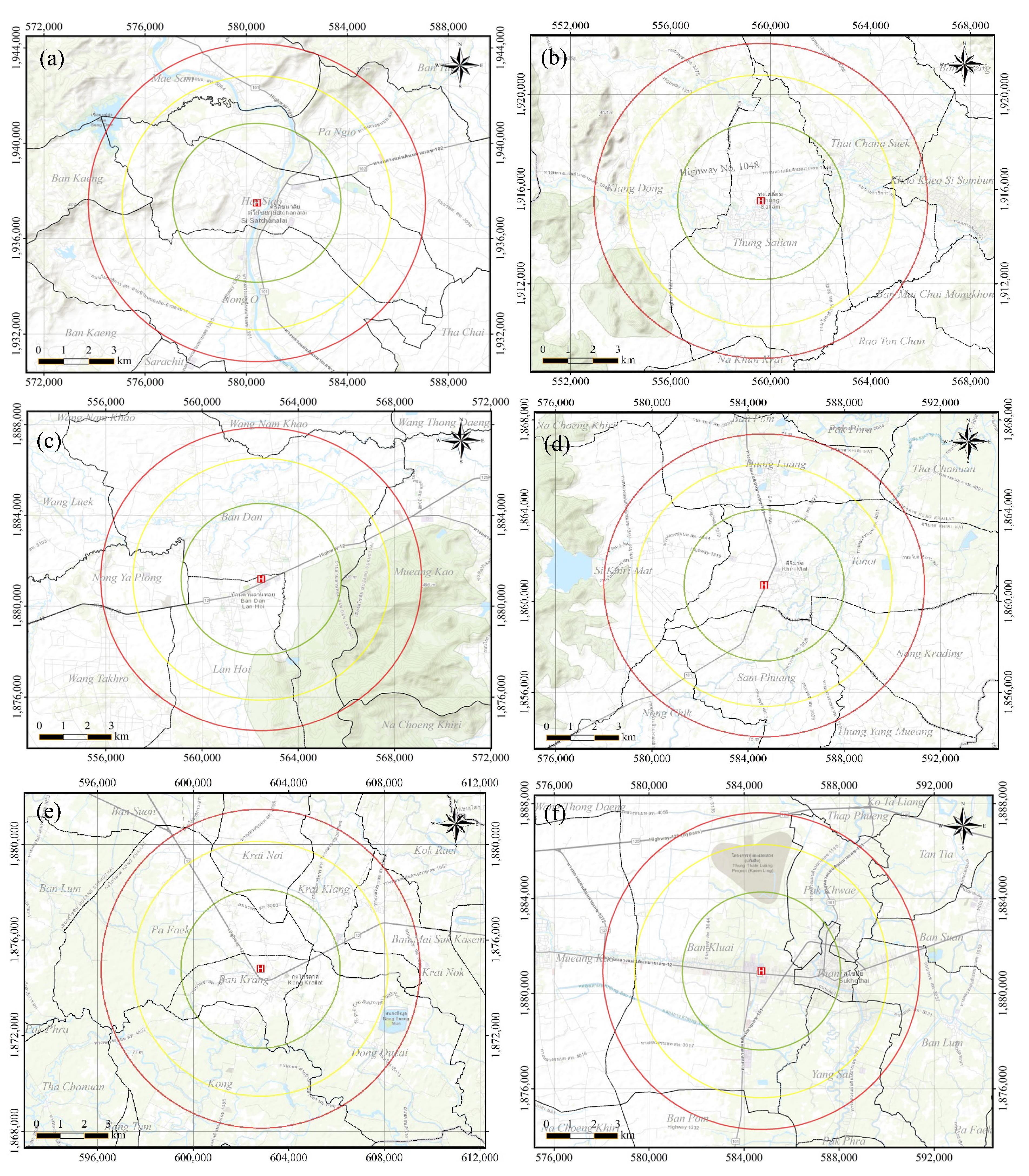
Figure 5: EMS coverage areas determined from response
time of 5, 8, and 10 minutes
(a) Si Satchanalai (b) Thung Saliam (c) Ban Dan Lan Hoi (d) Khiri Mat (e) Kong Krailat, (f) Mueang Sukhothai
(g) Sawankhalok (h) Si Nakhon (i) Si Samrong
Additionally, some hospitals, such as Ban Dan Lan Hoi, Kong Krailat,
and Mueang Sukhothai, are situated along Highway 12, while Khiri Mat
and Si Samrong hospitals are located along National Highway 101.
Consequently, the coverage distances are likely to increase with higher
average ambulance speeds. The response time coverage areas vary by
district in Sukhothai Province. Some districts benefit from shorter
response times, providing faster EMS access, while others, particularly
those with challenging terrain or located farther from emergency
facilities, experience longer response times. In districts with shorter
response times, EMS coverage is more comprehensive, ensuring that a
greater percentage of the population can receive timely emergency care.
Conversely, in districts with longer response times, particularly in
the mountainous regions such as Si Satchanalai, Thung Saliam, and Ban
Dan Lan Hoi, EMS coverage is less extensive, potentially delaying
access to emergency services. This disparity highlights the need for
targeted improvements in EMS infrastructure and resource allocation to
ensure more equitable access to emergency care across the province. The
figure also reveals that no district is fully covered within a
10-minute response time, particularly in sub-districts that are far from
the central city area (Nai Muaeng). The response time coverage area for
each district is detailed in Table 3. The table presents the Emergency
Medical Services (EMS) coverage areas, measured as a percentage of the
total district area, for various response times (5, 8, and 10 minutes)
across nine districts in Sukhothai Province. The total area of each
district is also provided, offering insight into the extent of EMS
reach relative to the geographical size of the districts.
The data reveal significant disparities in EMS coverage across
different districts. For example, Si Nakhon, despite being one of the smaller districts by area (181.71
sq.km), demonstrates the highest percentage of coverage at all response
times: 4.80% for a 5-minute response, 12.29% for an 8-minute response,
and 19.21% for a 10-minute response.
Table 3: Response time coverage areas by districts in
Sukhothai province
|
No
|
District
|
Total Area [sq.km]
|
EMS Coverage area [%]
|
|
5 min
|
8 min
|
10 min
|
|
1
|
Mueang Sukhothai
|
557.57
|
1.57
|
4.01
|
6.26
|
|
2
|
Ban Dan Lan Hoi
|
957.53
|
0.91
|
2.33
|
3.65
|
|
3
|
Khiri Mat
|
657.83
|
1.33
|
3.40
|
5.31
|
|
4
|
Kong Krailat
|
442.32
|
1.97
|
5.05
|
7.89
|
|
5
|
Si Satchanalai
|
2,116.63
|
0.41
|
1.06
|
1.65
|
|
6
|
Si Samrong
|
612.46
|
1.42
|
3.65
|
5.70
|
|
7
|
Sawankhalok
|
617.22
|
1.41
|
3.62
|
5.66
|
|
8
|
Si Nakhon
|
181.71
|
4.80
|
12.29
|
19.21
|
|
9
|
Thung Saliam
|
532.57
|
1.64
|
4.19
|
6.55
|
This suggests that EMS services in Si Nakhon are particularly
efficient, likely due to favorable infrastructure or proximity to EMS
facilities. Conversely, larger districts such as Si Satchanalai, with a
total area of 2,116.63 sq.km, show much lower EMS coverage percentages,
with only 0.41%, 1.06%, and 1.65% for 5, 8, and 10-minute response
times, respectively. This indicates significant challenges in providing
timely EMS access, possibly due to the district's large area and the
presence of difficult terrain, which is known to hinder rapid emergency
response.
The differences in EMS coverage percentages can be attributed to
several factors, including geographical challenges, infrastructure
availability, and the distribution of EMS resources. For instance, Ban
Dan Lan Hoi, with a relatively large area of 957.53 sq.km, also
exhibits low coverage percentages of 0.91%, 2.33%, and 3.65% for the
respective response times. These figures highlight the limitations
faced in reaching remote or less accessible regions, where mountainous
terrain and sparse road networks may impede the speed and efficiency of
EMS response. The variations in EMS coverage underscore the need for a
strategic allocation of EMS resources. Districts like Si Nakhon, with
high coverage despite a smaller total area, could serve as models for
optimizing EMS deployment strategies. On the other hand, districts with
extensive areas and low coverage percentages, such as Si Satchanalai and
Ban Dan Lan Hoi, may require additional EMS units, improved road
networks, or the establishment of new EMS stations to enhance coverage
and reduce response times.
In summary, Table 3 illustrates the uneven distribution of EMS coverage
across the districts of Sukhothai Province, highlighting the challenges
and limitations faced in ensuring equitable emergency medical care. The
data suggest a pressing need for targeted improvements in EMS
infrastructure, particularly in larger and more geographically
challenging districts. By addressing these disparities, it is possible
to improve emergency response times and ensure that all residents of
Sukhothai Province have access to timely medical assistance.
5. Conclusion
This study analyzed Emergency Medical Services (EMS) coverage areas in
Sukhothai Province, Thailand, using various response times and
distances. The findings reveal significant disparities in EMS coverage
across the province's nine districts. While densely populated areas
such as Mueang Sukhothai, Kong Krailat, and Si Nakhon are generally
well-served within a 20-minute response time, more remote and
mountainous regions face considerable challenges in accessing timely
emergency care. The analysis shows that even with a 30-minute response
time, which covers 82.77% of the total area, certain mountainous
regions in Si Satchanalai and Ban Dan Lan Hoi districts remain
unreached. This highlights the impact of geographical factors and
resource distribution on EMS effectiveness. The study also demonstrates
that no district achieves full coverage within a 10-minute response
time, particularly in sub-districts far from central city areas.
These findings underscore the need for strategic improvements in EMS
infrastructure and resource allocation. To enhance emergency care
access across Sukhothai Province, policymakers should consider:
-
Establishing additional EMS stations in underserved areas
-
Improving road networks in challenging terrains
-
Optimizing the distribution of EMS resources based on
population density and geographical constraints
-
Exploring alternative solutions for hard-to-reach areas, such
as air ambulance services
By addressing these disparities, Sukhothai Province can work towards
ensuring more equitable and timely access to emergency medical services
for all its residents, ultimately improving health outcomes and
emergency response capabilities.
6. Limitations
The study's limitations primarily stem from the reliance on GIS-based
analysis, which, while robust, cannot account for all real-world
variables affecting EMS response times, such as traffic conditions,
road quality, and weather events. Additionally, the static nature of
the coverage area maps does not reflect potential changes in population
density, road infrastructure, or EMS resource availability over time.
The study also assumes optimal EMS operation without considering
possible operational inefficiencies or delays. Future research could
benefit from integrating dynamic data and real-time analytics to provide
a more comprehensive assessment of EMS effectiveness. Furthermore, the
scope is limited to Sukhothai Province, and the findings may not be
directly applicable to other regions with different geographic or
socio-economic characteristics.
References
[1] Sittichanbuncha, Y., Prachanukool, T., Sarathep, P. and
Sawanyawisuth, K., (2014). An Emergency Medical Service System in
Thailand: Providers’ Perspectives.
The Journal of the Medical Association of Thailand
, Vol. 97(10), 1016-1021.
https://thaiscience.info/Journals/Article/JMAT/10970929.pdf.
[2] Hengrasmee, C., (N.D.).
EMS: The History and Principles of System Design. Department of
Emergency Medicine
. Faculty of Medicine. Vajira Hospital, Navamindradhiraj University.
[Online]. Available:
https://tcep.or.th/sites/default/files/ems_medical_director_tcep2017_history_of_ems.pdf.
[Accessed Apr. 14, 2024].
[3] National Institute for Emergency Medicine. (2024). Annual Report
2023. [Online] Available:
https://www.niems.go.th/pdfviewer/index.html.
[Accessed Feb. 14, 2024].
[4] The National Institute for Emergency Medicine. (2010). About
NIEM. [Online]. Available:
https://www.niems.go.th/1/SubWebsite/?id=1096,
2024].
[5] Al-Shaqsi, S, Z., (2010). Response Time as a Sole Performance
Indicator in EMS: Pitfalls and Solutions.
Open Access Emergency Medicine
, Vol. 2, 1-6.
https://doi.org/10.2147/OAEM.S8510.
[6] Cabral, E., Wilkson, C., Davidson, F., Danylo, V., Júnior, C.,
J., Ricardo, S., Amália, R., Irami, A. and Aldo, M., (2018). Response
Time in the Emergency Services. Systematic Review.
Acta Cirurgica Brasileira
, Vol. 33, 1110-1121.
https://doi.org/10.1590/s0102-865020180120000009.
[7] Luqman, M. and Khan, S. U., (2021). Geospatial Application to
Assess the Accessibility to the Health Facilities in Egypt.
The Egyptian Journal of Remote Sensing and Space Sciences
, Vol. 24(3), 699-705.
https://doi.org/10.1016/j.ejrs.2021.02.005.
[8] Rekha, R. S., Wajid, S., Radhakrishnan, N. and Mathew, S.,
(2017). Accessibility Analysis of Health Care Facility using Geospatial
Techniques. Transportation Research Procedia, Vol. 27,
1163-1170.
https://doi.org/10.1016/j.trpro.2017.12.078.
[9] Thipthimwong, K. and Noosorn, N., (2023). Analysis of Accident
Sites from Motorcycles among High School Students Using Geographic
Information Systems, Sukhothai Province.
International Journal of Geoinformatics
, Vol. 19(3), 45–56.
https://doi.org/10.52939/ijg.v19i3.2603.
[10] Office of Registration Administration, Department of Provincial
Administration. (2024). Population statistics by the Civil Registration
Bureau (monthly). [Online]. Available:
https://stat.bora.dopa.go.th/stat/statnew/statMONTH/statmonth/#/mainpage.
[11] Hfocus, (2015).
Emergency Medical Experts Oppose 80 km/h Speed Limit
. Saying It Doesn't Solve the Problem. [Online]. Available:
https://www.hfocus.org/content/2015/04/9782".
[12] Tanthanapanyakorn, P. and Areesantichai, C., (2024). Spatial
Distribution Analysis of Cannabis-Infused Food and Drink Establishments
in Pathum Thani Province, Thailand Through Geographic Information
Systems. International Journal of Geoinformatics, Vol. 20(1),
25–39.
https://doi.org/10.52939/ijg.v20i1.3023.
[13] Thammaboribal, P., Tripathi, N. K., Ninsawat, S. and Indrajit, P.,
(2022). Earthquake Precursory Detection Using Diurnal GPS-TEC and
Kriging Interpolation Maps: 12 May 2008, Mw7.9 Wenchuan Case Study.
MethodsX, Vol. 9.
https://doi.org/10.1016/j.mex.2022.10161.
[14] Alshammari, B., (2024). Analysis of Hotel Distribution Patterns in
Hail, Saudi Arabia, Using Geographic Information Systems (GIS).
International Journal of Geoinformatics
, Vol. 20(6). 43-56.
https://doi.org/10.52939/ijg.v20i6.3333.
[15] Cojanu, V., Robert, D. and Stupariu, I., (2012). The Accessibility
Buffer – A Basic GIS Tool in Determining the Competitive Potential
Index. Landscape, Environment, European Identity, Vol. 14,
237-246.
https://doi.org/10.1016/j.proe.